
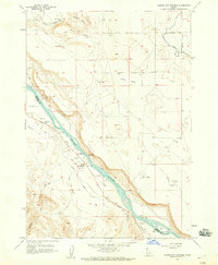
1957 Map of Sands Basin
USGS Topo · Published 1959About this map
Riverside and the winding course of the Snake River anchor the northeastern corner of this 1957 survey, where a complex network of canals and islands like Fruit Island supported the local agricultural economy. Moving southwest into the higher elevations, the landscape transitions from irrigated flats to a rugged terrain of high peaks and basins, including the namesake Sands Basin and Shares Basin. The map captures an era of specific land uses, from a designated Boy Scout Camp and an abandoned Target to several family-named locations such as Bush Ranch and French John Hill.
Find a feature on this map
68 named features on this map. Tap any name to fly to it.
Don’t see what you’re looking for? This feature index may not catch every label — zoom into the map to look around manually.
Map Details
Editions of this 1957 Sands Basin Map
This is the sole edition of this map. No revisions or reprints were ever made.
Other maps of this area

1892 · Silver City
USGS Topo · 1:125,000

1894 · Silver City
USGS Topo · 1:125,000

1898 · Nampa
USGS Topo · 1:125,000

1898 · Silver City
USGS Topo · 1:125,000

1906 · Mitchell Butte
USGS Topo · 1:125,000

1955 · Boise
USGS Topo · 1:250,000

1957 · Opalene Gulch
USGS Topo · 1:24,000

1957 · Wilson Peak
USGS Topo · 1:24,000

1958 · Boise
USGS Topo · 1:250,000
1958 · Givens Hot Springs
USGS Topo · 1:24,000