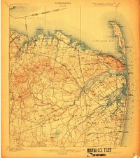
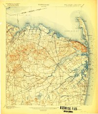
1901 Map of Sandy Hook
USGS Topo · Published 1912About this map
Fort Hancock and the Sandy Hook Light dominate the northern peninsula of this Monmouth County coast, shielding the entrance to Sandy Hook Bay. The landscape is a intricate network of maritime and rail infrastructure, where the Central Railroad of New Jersey and the New York and Long Branch Railroad connect coastal resorts like Seabright and Monmouth Beach to inland hubs. South of the Highlands of Navesink, the terrain transitions from harbor settlements such as Keyport and Atlantic Highlands to the fertile agricultural lands of Middletown and Holmdel. Further inland, family-named landmarks and geographic features like Hockhockson Swamp and Crawford Hill provide a window into the late nineteenth-century rural interior, while the series of Life Saving Stations, including L. S. Station Seabright, underscore the era's critical maritime safety efforts along the Atlantic Ocean.
Find a feature on this map
145 named features on this map. Tap any name to fly to it.
Don’t see what you’re looking for? This feature index may not catch every label — zoom into the map to look around manually.
Map Details
Editions of this 1901 Sandy Hook Map
6 editions found

Other maps of this area

1888 · Plainfield
USGS Topo · 1:62,500

1888 · New Brunswick
USGS Topo · 1:62,500

1888 · Asbury Park
USGS Topo · 1:62,500

1888 · Cassville
USGS Topo · 1:62,500

1888 · Sandy Hook
USGS Topo · 1:62,500

1889 · Brooklyn
USGS Topo · 1:62,500

1891 · Brooklyn
USGS Topo · 1:62,500

1893 · New Brunswick
USGS Topo · 1:62,500

1893 · Plainfield
USGS Topo · 1:62,500

1893 · Sandy Hook
USGS Topo · 1:62,500