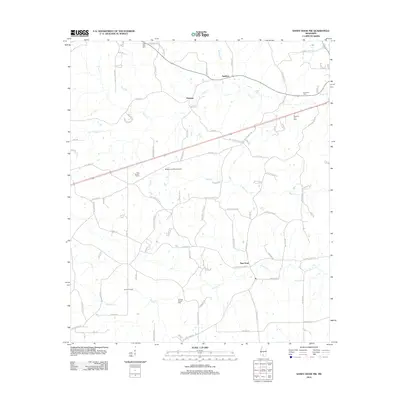
2012 Map of Sandy Hook NW
USGS Topo · Published 2012About this map
Tenmile Creek and its southern tributaries define the rural landscape of southern Marion County, where timber and agriculture have long shaped the local economy. In this 2012 survey, the Knoxo Oil Field stands as a clear marker of the region’s industrial history, contrasted by the enduring presence of family and community centers such as Little Rock Cem and Turnage Chapel Cem. Small settlements like New Hope and Hamage serve as local anchors, connected by a network of rural roads such as New Hope Kokomo Rd. The map also captures specific agricultural and transportation infrastructure, including Prisk Poultry Farms and the Browns Landing Airport, reflecting the diverse land use of this Piney Woods corner near the Pearl River valley.
Find a feature on this map
90 named features on this map. Tap any name to fly to it.
Don’t see what you’re looking for? This feature index may not catch every label — zoom into the map to look around manually.
Map Details
Editions of this 2012 Sandy Hook NW Map
This is the sole edition of this map. No revisions or reprints were ever made.
Other maps of this area

1953 · Hattiesburg
USGS Topo · 1:250,000

1953 · Natchez
USGS Topo · 1:250,000

1956 · Natchez
USGS Topo · 1:250,000

1958 · Hattiesburg
USGS Topo · 1:250,000

1959 · Natchez
USGS Topo · 1:250,000

1970 · Columbia South
USGS Topo · 1:24,000

1970 · Sandy Hook NW
USGS Topo · 1:24,000
1970 · Tylertown SE
USGS Topo · 1:24,000

1970 · Kokomo
USGS Topo · 1:24,000

1970 · Darbun
USGS Topo · 1:24,000