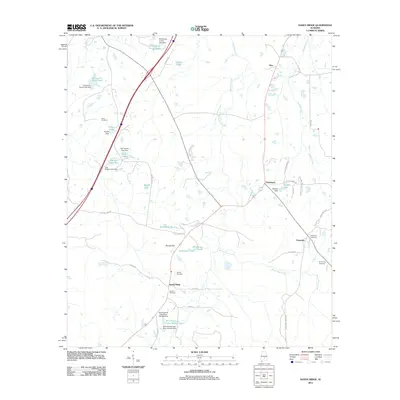
2011 Map of Sandy Ridge
USGS Topo · Published 2011About this map
Sandy Ridge and its neighboring rural settlements of Zion and Davenport define the interior of Lowndes County in this early 21st-century study. The landscape is heavily marked by family-named landholdings and small-scale water management, evidenced by the numerous named ponds and dams including W D Farrior Junior Lake Dam, Gaston Lake, and the W E Pritchett Lake Number One complex. This network of man-made water features suggests a land primarily used for agriculture and private recreation. For local historians and genealogists, the map provides precise locations for several family burial grounds, including Lamar Cemetery, Sawyer Cemetery, and Armstrong Cemetery. The road network, from the major thoroughfare of Rooster Rd to smaller routes like Julian Town Rd and Means Cemetery Rd, shows the connectivity of this community before the significant changes of the modern decade.
Find a feature on this map
51 named features on this map. Tap any name to fly to it.
Don’t see what you’re looking for? This feature index may not catch every label — zoom into the map to look around manually.
Map Details
Editions of this 2011 Sandy Ridge Map
This is the sole edition of this map. No revisions or reprints were ever made.
Other maps of this area

1953 · Montgomery
USGS Topo · 1:250,000

1953 · Andalusia
USGS Topo · 1:250,000

1956 · Montgomery
USGS Topo · 1:250,000

1957 · Montgomery
USGS Topo · 1:250,000

1957 · Andalusia
USGS Topo · 1:250,000

1957 · Letohatchee
USGS Topo · 1:62,500

1971 · Fort Deposit
USGS Topo · 1:24,000

1971 · Danielsville
USGS Topo · 1:24,000
1971 · Lapine
USGS Topo · 1:24,000
1981 · Snowdoun
USGS Topo · 1:24,000