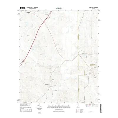
2014 Map of Sandy Ridge
USGS Topo · Published 2014About this map
Sandy Ridge serves as a central hub in this Southern Alabama landscape where the borders of Lowndes, Montgomery, and Crenshaw counties converge. The area is characterized by a network of rural roads and scattered family-named cemeteries, such as Magnolia Cem and Payne Cem, which offer significant value for genealogical research. Small settlements like Letohatchee and Davenport are situated along key transport corridors, including Us 31 and Al 97, reflecting the long-standing agricultural and residential patterns of the region.
Find a feature on this map
49 named features on this map. Tap any name to fly to it.
Don’t see what you’re looking for? This feature index may not catch every label — zoom into the map to look around manually.
Map Details
Editions of this 2014 Sandy Ridge Map
This is the sole edition of this map. No revisions or reprints were ever made.
Other maps of this area

1953 · Montgomery
USGS Topo · 1:250,000

1953 · Andalusia
USGS Topo · 1:250,000

1956 · Montgomery
USGS Topo · 1:250,000

1957 · Montgomery
USGS Topo · 1:250,000

1957 · Andalusia
USGS Topo · 1:250,000

1957 · Letohatchee
USGS Topo · 1:62,500

1971 · Fort Deposit
USGS Topo · 1:24,000

1971 · Danielsville
USGS Topo · 1:24,000
1971 · Lapine
USGS Topo · 1:24,000
1981 · Snowdoun
USGS Topo · 1:24,000