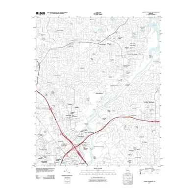
2011 Map of Sandy Springs
USGS Topo · Published 2011About this map
Blackjack Mountain rises above a landscape defined by the winding course of the Chattahoochee River and its numerous shoals, including Chochran Shoals and Thornton Shoals. This early 21st-century documentation of the Atlanta northern perimeter captures a suburban transition, where long-standing community hubs like the Marietta Campground and Mount Bethel persist alongside dense residential developments like Indian Hills and Sibley Forest. The reliance on the river for infrastructure is evident at the Morgan Falls Dam and the Morgan Falls Reservoir, while numerous family and community burial grounds, such as Antioch Cemetery and Sardis Cemetery, offer critical touchstones for local genealogists. Major transport arteries like the Johnson Ferry Bridge and the intersection of Interstate 285 and Interstate 75 highlight the region's role as a primary corridor for commerce and movement.
Find a feature on this map
160 named features on this map. Tap any name to fly to it.
Don’t see what you’re looking for? This feature index may not catch every label — zoom into the map to look around manually.
Map Details
Editions of this 2011 Sandy Springs Map
This is the sole edition of this map. No revisions or reprints were ever made.
Other maps of this area

1888 · Atlanta
USGS Topo · 1:125,000

1890 · Suwanee
USGS Topo · 1:125,000

1890 · Cartersville
USGS Topo · 1:125,000

1890 · Atlanta
USGS Topo · 1:125,000

1891 · Marietta
USGS Topo · 1:125,000

1891 · Cartersville
USGS Topo · 1:125,000

1892 · Atlanta
USGS Topo · 1:125,000

1894 · Suwanee
USGS Topo · 1:125,000

1895 · Atlanta
USGS Topo · 1:125,000

1895 · Marietta
USGS Topo · 1:125,000