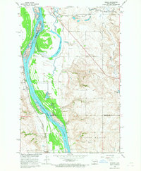
1966 Map of Sanger
USGS Topo · Published 1967About this map
The Missouri River forms the dominant corridor through this mid-1960s landscape, serving as a county boundary between Oliver, McLean, and Burleigh. Along its western bank, the small settlement of Sanger sits adjacent to the Northern Pacific railroad line, while the Soo Line traverses the northern section near the Merida siding. The terrain is defined by a complex network of backwaters and seasonal lakes, including Painted Woods Lake, Wildwood Lake, and Beaver Lake, which reflect the river's historical meanders across the floodplain. Conservation and recreation areas are well-established, with the National Wildlife Refuge protecting the northern marshes and Molander State Park situated at the southern edge. The presence of numerous Gravel Pits and the extensive Painted Woods forest highlight a balance between industrial resource extraction and the preservation of the river's natural riparian environment.
Find a feature on this map
23 named features on this map. Tap any name to fly to it.
Don’t see what you’re looking for? This feature index may not catch every label — zoom into the map to look around manually.
Map Details
Editions of this 1966 Sanger Map
This is the sole edition of this map. No revisions or reprints were ever made.
Other maps of this area

1949 · Turtle Creek
USGS Topo · 1:62,500

1949 · Washburn
USGS Topo · 1:62,500

1950 · Wilton
USGS Topo · 1:62,500

1954 · McClusky
USGS Topo · 1:250,000

1958 · McClusky
USGS Topo · 1:250,000

1961 · Turtle Creek SW
USGS Topo · 1:24,000

1961 · Washburn
USGS Topo · 1:24,000

1961 · Turtle Creek SE
USGS Topo · 1:24,000

1966 · Price
USGS Topo · 1:24,000

1966 · Wilton SE
USGS Topo · 1:24,000