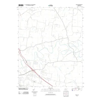
2010 Map of Sango
USGS Topo · Published 2010About this map
Sango serves as the central hub of this Montgomery County landscape, where modern residential development meets a deeply established rural road network. The winding path of the Red River and its confluence with the Sulphur Fork Red River define the northern and eastern reaches of the area, creating a complex drainage system supported by Passenger Creek and Browns Branch. The infrastructure reflects a long history of transit between regional centers, anchored by thoroughfares like the Old Clarksville Springfield Rd and Trough Springs Rd. For those tracing local heritage, the map identifies Rest Haven Memorial Gardens and numerous family-named routes such as Killebrew Rd and Grants Chapel Rd, which suggest the locations of early homesteads and community gathering points within this evolving Tennessee terrain.
Find a feature on this map
40 named features on this map. Tap any name to fly to it.
Don’t see what you’re looking for? This feature index may not catch every label — zoom into the map to look around manually.
Map Details
Editions of this 2010 Sango Map
This is the sole edition of this map. No revisions or reprints were ever made.
Other maps of this area

1944 · Clarksville
USGS Topo · 1:50,000

1950 · Allensville
USGS Topo · 1:24,000

1950 · Guthrie
USGS Topo · 1:24,000

1951 · Hammacksville
USGS Topo · 1:24,000

1951 · Clarksville
USGS Topo · 1:24,000

1956 · Nashville
USGS Topo · 1:250,000

1957 · Adams
USGS Topo · 1:24,000

1957 · Pleasant View
USGS Topo · 1:24,000

1957 · Henrietta
USGS Topo · 1:24,000

1957 · Sango
USGS Topo · 1:24,000
Featured Places
- Clarksville, TN
- Sango, TN
- Paula Heights, Clarksville
- Red River Estates, Clarksville
- Royalty Acres, Clarksville