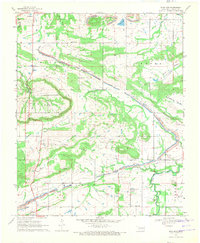
1969 Map of Sans Bois
USGS Topo · Published 1971About this map
Sans Bois Creek flows across this landscape in Haskell County, anchoring a terrain defined by extensive industrial and natural features during the late 1960s. The map captures the significant presence of extractive industries, with numerous strip mine sites and gas wells marking the valleys of Machire and Beaver. This juxtaposition of resource extraction and community life is evident in the quiet rural settlements of Whitefield and Kinta.
Find a feature on this map
26 named features on this map. Tap any name to fly to it.
Don’t see what you’re looking for? This feature index may not catch every label — zoom into the map to look around manually.
Map Details
Editions of this 1969 Sans Bois Map
This is the sole edition of this map. No revisions or reprints were ever made.
Other maps of this area

1900 · Sansbois
USGS Topo · 1:125,000

1909 · Sans Bois
USGS Topo · 1:125,000

1911 · Sansbois
USGS Topo · 1:125,000

1946 · Fort Smith
USGS Topo · 1:250,000

1962 · Stigler East
USGS Topo · 1:24,000

1962 · Stigler West
USGS Topo · 1:24,000

1963 · Porum
USGS Topo · 1:24,000

1965 · Fort Smith
USGS Topo · 1:250,000

1967 · Fort Smith
USGS Topo · 1:250,000
1968 · Lafayette
USGS Topo · 1:24,000