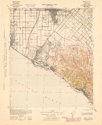
1942 Map of Santa Ana
USGS Topo · Published 1943About this map
Santa Ana and the surrounding coastal plains of Orange County appear here as a grid of citrus groves, bean fields, and emerging seaside communities during the early 1940s. The Santa Ana River cuts a wide path through the center of the sheet, separating the established city from the developing tracts of Santa Ana Gardens and Greenville. Along the coast, the geography of Newport Bay and the San Joaquin Hills dictates the layout of Newport Beach and Corona Del Mar. This era is defined by the heavy presence of the Southern Pacific and Atchison Topeka and Santa Fe railroads, which served the region's agricultural and industrial base. Local education is anchored by rural institutions such as Greenville Sch and Paularino Sch, while the interior terrain features landmarks like French Hill and the Twenty Ranch Gun Club Road, reflecting a landscape still transitioning from open ranchland to suburban development.
Find a feature on this map
80 named features on this map. Tap any name to fly to it.
Don’t see what you’re looking for? This feature index may not catch every label — zoom into the map to look around manually.
Map Details
Editions of this 1942 Santa Ana Map
2 editions found
Other maps of this area

1896 · Santa Ana
USGS Topo · 1:62,500

1896 · Anaheim
USGS Topo · 1:62,500

1896 · Las Bolsas
USGS Topo · 1:62,500

1896 · Downey
USGS Topo · 1:62,500

1898 · Anaheim
USGS Topo · 1:62,500

1899 · Downey
USGS Topo · 1:62,500

1901 · Southern California Sheet No. 1
USGS Topo · 1:250,000

1901 · Santa Ana
USGS Topo · 1:62,500

1901 · Anaheim
USGS Topo · 1:62,500

1902 · Capistrano
USGS Topo · 1:125,000