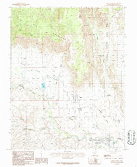
1986 Map of Santa Clara
USGS Topo · Published 1987About this map
Snow Canyon State Park dominates the eastern corridor of this Utah landscape, revealing a transition from the basaltic flows of the North Black Rocks and South Black Rocks to the elevation of the Red Mountains. The town of Ivins is depicted just east of its namesake Ivins Res, showing its mid-1980s street grid and proximity to the Santa Clara Bench. To the south, the Santa Clara River winds through the valley, anchoring the historic settlement of Santa Clara and extending toward the northwestern edge of St George. The presence of a Graveyard near the river and named terrain like Land Hill and Wittwer Canyon highlights the long-standing agricultural and ranching heritage of this corner of Washington County, where the desert washes and rocky outcrops dictated the patterns of early development.
Find a feature on this map
21 named features on this map. Tap any name to fly to it.
Don’t see what you’re looking for? This feature index may not catch every label — zoom into the map to look around manually.
Map Details
Editions of this 1986 Santa Clara Map
This is the sole edition of this map. No revisions or reprints were ever made.
Other maps of this area

1885 · St. George
USGS Topo · 1:250,000

1891 · St. George
USGS Topo · 1:250,000

1953 · Cedar City
USGS Topo · 1:250,000

1954 · Beaver Dam Mts NE
USGS Topo · 1:24,000

1954 · Gunlock
USGS Topo · 1:24,000

1954 · Beaver Dam Mts SE
USGS Topo · 1:24,000

1954 · St. George
USGS Topo · 1:62,500
1956 · St. George SE
USGS Topo · 1:24,000

1956 · St. George NW
USGS Topo · 1:24,000

1956 · St. George NE
USGS Topo · 1:24,000