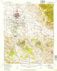
1947 Map of Santa Maria
USGS Topo · Published 1954About this map
The Santa Maria Valley and surrounding central coast hills are captured here shortly after the war, showing a landscape defined by intensive agriculture and expanding energy infrastructure. The city of Santa Maria serves as the regional hub, flanked by early aviation sites like Machado Airfield and Hancock Airport. To the south, the terrain transitions into the Casmalia Hills and Los Alamos Hills, where the presence of an extensive Oil Field and numerous Oil Tanks near Orcutt indicates the scale of the local petroleum industry during this period.
Find a feature on this map
53 named features on this map. Tap any name to fly to it.
Don’t see what you’re looking for? This feature index may not catch every label — zoom into the map to look around manually.
Map Details
Editions of this 1947 Santa Maria Map
This is the sole edition of this map. No revisions or reprints were ever made.
Other maps of this area

1897 · Arroyo Grande
USGS Topo · 1:62,500

1900 · San Luis
USGS Topo · 1:125,000

1905 · Guadalupe
USGS Topo · 1:125,000

1905 · Lompoc
USGS Topo · 1:125,000

1922 · Nipomo
USGS Topo · 1:62,500

1937 · Branch Mtn
USGS Topo · 1:48,000

1942 · Point Arguello
USGS Topo · 1:62,500

1942 · Guadalupe
USGS Topo · 1:125,000

1942 · Lompoc
USGS Topo · 1:125,000

1942 · Lompoc
USGS Topo · 1:62,500