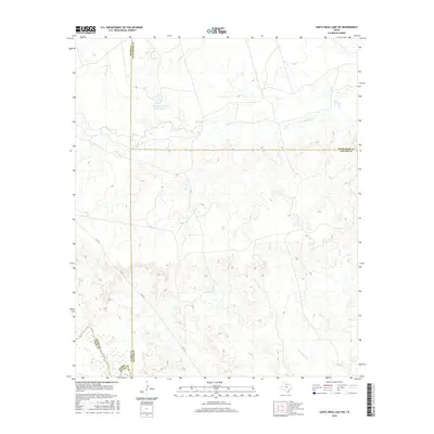
2016 Map of Santa Rosa Lake SW
USGS Topo · Published 2016About this map
The expansive Waggoner Ranch Lake Number 8 and the winding course of the North Wichita River define this rural landscape at the intersection of Foard, Wilbarger, Baylor, and Knox Counties. The terrain is characterized by a dense network of intermittent drainage systems, including Rose Hollow Cr, Crooked Cr, and S Beaver Cr, which carve through the plains. Aside from the presence of FM 1919, the area remains largely undeveloped, reflecting the enduring legacy of large-scale Texas ranching operations. The map provides a precise look at the hydrology of the region, showing how seasonal waterways like Fish Cr feed into the larger river system, a critical resource for the local cattle industry in this part of north-central Texas.
Find a feature on this map
11 named features on this map. Tap any name to fly to it.
Don’t see what you’re looking for? This feature index may not catch every label — zoom into the map to look around manually.
Map Details
Editions of this 2016 Santa Rosa Lake SW Map
This is the sole edition of this map. No revisions or reprints were ever made.
Other maps of this area

1954 · Wichita Falls
USGS Topo · 1:250,000

1958 · Wichita Falls
USGS Topo · 1:250,000

1966 · Santa Rosa Lake
USGS Topo · 1:24,000

1966 · Santa Rosa Lake SW
USGS Topo · 1:24,000

1966 · Soap Creek
USGS Topo · 1:24,000

1966 · Colwell Creek
USGS Topo · 1:24,000

1966 · Vera
USGS Topo · 1:24,000

1966 · Northwest Lake Kemp
USGS Topo · 1:24,000

1966 · Southwest Lake Kemp
USGS Topo · 1:24,000

1966 · Thalia
USGS Topo · 1:24,000