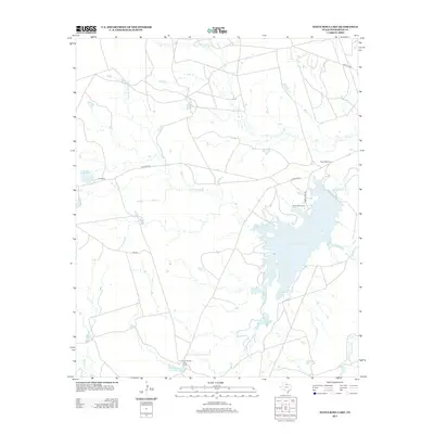
2013 Map of Santa Rosa Lake
USGS Topo · Published 2013About this map
Santa Rosa Lake serves as the central focal point of this North Texas landscape, where the seasonal hydrology of Beaver Cr and Grapevine Cr feeds into the reservoir. The map reveals a specialized ranching and agricultural economy, noted by the presence of the Santa Rosa Ranch and Santa Rosa Pens to the north. A network of rural arteries, including Gin Rd and 4 Corners Rd, connects isolated camps such as D's Camp and the Four Corners Cow Camp. These small, named outposts suggest a pattern of seasonal or operational habitation common in the expansive cattle country of Wilbarger County. Smaller water features like Cedar Bluff Tank and D Camp Lake further emphasize the critical nature of water management in this prairie environment.
Find a feature on this map
18 named features on this map. Tap any name to fly to it.
Don’t see what you’re looking for? This feature index may not catch every label — zoom into the map to look around manually.
Map Details
Editions of this 2013 Santa Rosa Lake Map
This is the sole edition of this map. No revisions or reprints were ever made.
Other maps of this area

1954 · Wichita Falls
USGS Topo · 1:250,000

1955 · Lawton
USGS Topo · 1:250,000

1958 · Wichita Falls
USGS Topo · 1:250,000

1958 · Davidson
USGS Topo · 1:62,500

1958 · Vernon
USGS Topo · 1:62,500

1966 · Santa Rosa Lake
USGS Topo · 1:24,000

1966 · Santa Rosa Lake SW
USGS Topo · 1:24,000

1966 · Grayback
USGS Topo · 1:24,000

1966 · Northeast Lake Kemp
USGS Topo · 1:24,000

1966 · Northwest Lake Kemp
USGS Topo · 1:24,000