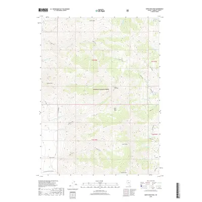
2018 Map of Santa Rosa Peak
USGS Topo · Published 2018About this map
Santa Rosa Peak dominates the center of this high-elevation landscape within the Humboldt National Forest. Part of the larger Santa Rosa Range, the terrain is defined by sharp elevation shifts and deep drainages. The map records a network of high-country routes, most notably the Summit Trail which traverses several ridgelines, and the New Motor Trail providing access to the western slopes. Numerous watercourses originate in these heights, including McConnell Creek, Rock Creek, and Mullinix Creek, flowing through steep valleys like Horse Canyon and Falls Canyon. The drainage patterns and named peaks like Sawtooth Mtn and Paradise Peak offer critical orientation for studying the historical land use and early surveying of this portion of Humboldt County.
Find a feature on this map
36 named features on this map. Tap any name to fly to it.
Don’t see what you’re looking for? This feature index may not catch every label — zoom into the map to look around manually.
Map Details
Editions of this 2018 Santa Rosa Peak Map
This is the sole edition of this map. No revisions or reprints were ever made.
Other maps of this area

1882 · Paradise
USGS Topo · 1:250,000

1893 · Paradise
USGS Topo · 1:250,000

1955 · McDermitt
USGS Topo · 1:250,000

1958 · Paradise Valley
USGS Topo · 1:62,500

1958 · Awakening Peak
USGS Topo · 1:62,500

1959 · McDermitt
USGS Topo · 1:250,000

1959 · Orovada
USGS Topo · 1:62,500

1959 · Hinkey Summit
USGS Topo · 1:62,500
1982 · Andorno Ranch
USGS Topo · 1:24,000
1985 · Osgood Mts
USGS Topo · 1:100,000