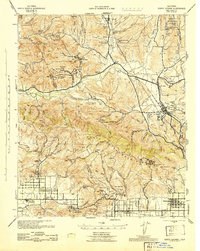
1943 Map of Santa Susana
USGS Topo · Published 1943About this map
The Santa Clara River valley and the surrounding Santa Susana Mountains define a landscape transitioning from agricultural ranching to heavy petroleum extraction during the early 1940s. The region is dotted with numerous family-held and institutional properties such as the Hathaway Ranch, Newhall Ranch, and the Wayside Honor Farm. Significant industrial activity is concentrated in the Oak Canyon Oil Field and Newhall-Potrero Oil Field, reflecting the era's intensive resource development.
Find a feature on this map
98 named features on this map. Tap any name to fly to it.
Don’t see what you’re looking for? This feature index may not catch every label — zoom into the map to look around manually.
Map Details
Editions of this 1943 Santa Susana Map
This is the sole edition of this map. No revisions or reprints were ever made.
Other maps of this area

1894 · Los Angeles
USGS Topo · 1:62,500

1896 · Santa Monica
USGS Topo · 1:62,500

1898 · Santa Monica
USGS Topo · 1:62,500

1900 · Los Angeles
USGS Topo · 1:62,500

1900 · Fernando
USGS Topo · 1:62,500

1900 · Triunfo Pass
USGS Topo · 1:62,500

1900 · Piru
USGS Topo · 1:62,500

1901 · Southern California Sheet No. 1
USGS Topo · 1:250,000

1902 · Santa Monica
USGS Topo · 1:62,500

1903 · Calabasas
USGS Topo · 1:62,500