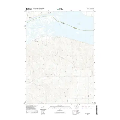
2014 Map of Santee
USGS Topo · Published 2014About this map
Santee occupies the bluffs above the Missouri River in this survey of the Nebraska-South Dakota borderlands. The landscape is defined by the expansive Lewis and Clark Lake to the north, where the river widens behind downstream impoundments, revealing a complex network of Sand Islands and shifting channels. This area, historically significant as part of the Santee Sioux Reservation, shows a distinct residential layout with streets like Medwakanton Ave and Leaf Shoots Dr situated near the river's edge. South of the settlement, the terrain transitions into a series of deeply etched drainages where Hoboe Cr, Lost Cr, and Howe Cr cut through the high ground. The map details the rural infrastructure connecting these plateaus, including Veterans Memorial Dr and numerous section-line roads such as 537 Ave, which provide access to the hinterlands of Knox County.
Find a feature on this map
26 named features on this map. Tap any name to fly to it.
Don’t see what you’re looking for? This feature index may not catch every label — zoom into the map to look around manually.
Map Details
Editions of this 2014 Santee Map
This is the sole edition of this map. No revisions or reprints were ever made.
Other maps of this area

1955 · Sioux City
USGS Topo · 1:250,000

1958 · Sioux City
USGS Topo · 1:250,000

1959 · Sioux City
USGS Topo · 1:250,000

1974 · Sparta
USGS Topo · 1:24,000

1974 · Lindy
USGS Topo · 1:24,000

1974 · Howe Creek
USGS Topo · 1:24,000

1974 · Bon Homme Colony
USGS Topo · 1:24,000
1977 · Springfield
USGS Topo · 1:24,000
1977 · Lindy
USGS Topo · 1:24,000
1977 · Howe Creek
USGS Topo · 1:24,000