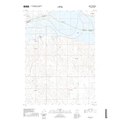
2017 Map of Santee
USGS Topo · Published 2017About this map
Santee occupies a significant position along the southern banks of the Missouri River in this 2017 survey of Knox County. The settlement is defined by a grid of streets including Main St, Redwing St, and Rosebud Ave, situated just south of the sprawling Sand Islands within Lewis and Clark Lake. The geography is characterized by the transition from the river's wide floodplains to the dissected uplands of northern Nebraska, where numerous drainages such as Lost Cr and Hoboe Cr cut through the terrain. The map traces the border between South Dakota and Nebraska, as well as the county line for Bon Homme and Knox counties, following the historical path of the river through the reservoir. This modern digital survey provides a precise layout of rural roads like 894 Rd and 538 Ave that connect the remote homesteads and agricultural plots of the region.
Find a feature on this map
31 named features on this map. Tap any name to fly to it.
Don’t see what you’re looking for? This feature index may not catch every label — zoom into the map to look around manually.
Map Details
Editions of this 2017 Santee Map
This is the sole edition of this map. No revisions or reprints were ever made.
Other maps of this area

1955 · Sioux City
USGS Topo · 1:250,000

1958 · Sioux City
USGS Topo · 1:250,000

1959 · Sioux City
USGS Topo · 1:250,000

1974 · Sparta
USGS Topo · 1:24,000

1974 · Lindy
USGS Topo · 1:24,000

1974 · Howe Creek
USGS Topo · 1:24,000

1974 · Bon Homme Colony
USGS Topo · 1:24,000
1977 · Springfield
USGS Topo · 1:24,000
1977 · Lindy
USGS Topo · 1:24,000
1977 · Howe Creek
USGS Topo · 1:24,000