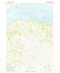
1978 Map of Santee
USGS Topo · Published 1978About this map
Lewis and Clark Lake dominates the northern landscape of this late-1970s survey, marking the watery border between Nebraska and South Dakota. The Santee Indian Res Bdy encompasses the settlement of Santee and the adjacent Santee Recreation Area, situated along the southern bluffs overlooking the Missouri River. To the north, the town of Springfield sits on higher ground above the river valley. The topography reveals a stark contrast between the wide, island-dotted channel and the deeply dissected drainage systems to the south, where Lost Creek, Hoboe Creek, and Howe Creek carve through the terrain. Numerous Cem sites and Gravel Pit operations are scattered across the uplands, reflecting a rural economy and long-standing community footprint within the reservation boundaries. This record captures the shoreline before decades of further siltation and development altered the Sand Islands and river reaches.
Find a feature on this map
16 named features on this map. Tap any name to fly to it.
Don’t see what you’re looking for? This feature index may not catch every label — zoom into the map to look around manually.
Map Details
Editions of this 1978 Santee Map
This is the sole edition of this map. No revisions or reprints were ever made.
Other maps of this area

1955 · Sioux City
USGS Topo · 1:250,000

1958 · Sioux City
USGS Topo · 1:250,000

1959 · Sioux City
USGS Topo · 1:250,000

1974 · Sparta
USGS Topo · 1:24,000

1974 · Lindy
USGS Topo · 1:24,000

1974 · Howe Creek
USGS Topo · 1:24,000

1974 · Bon Homme Colony
USGS Topo · 1:24,000
1977 · Springfield
USGS Topo · 1:24,000

1977 · Lindy
USGS Topo · 1:24,000
1977 · Howe Creek
USGS Topo · 1:24,000
Featured Places
- Santee, NE
- Springfield Township, SD
- Little Tabor Township, SD
- Bon Homme Township, SD
- Bon Homme County, SD