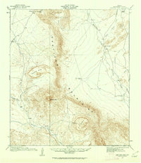
1917 Map of Santiago Peak
USGS Topo · Published 1962About this map
Santiago Peak anchors this Big Bend-area landscape, serving as a primary landmark in a region defined by high desert ranching and prominent geologic formations. Surveyed in 1917, the sheet documents a remote network of cattle operations including the Buttrill Ranch, Combs Cattle Co Ranch, and Schuler Ranch, illustrating the sparse but vital settlement pattern of Brewster County before modern development. The central Santiago Mountains and Cochran Mountains dictate the flow of ephemeral watercourses like Chalk Draw and Maravillas Creek. The presence of Maravillas Gap and named passes like Paso del Norte highlight the historical travel corridors used by early travelers moving toward Marathon or Boquillas. This mapping effort, led by topographic engineers C.H. Birdseye and Glenn S. Smith, provides an intricate view of the land as it was managed during the early twentieth-century ranching era.
Find a feature on this map
22 named features on this map. Tap any name to fly to it.
Don’t see what you’re looking for? This feature index may not catch every label — zoom into the map to look around manually.
Map Details
Editions of this 1917 Santiago Peak Map
3 editions found
Other maps of this area

1895 · Alpine
USGS Topo · 1:125,000

1917 · Agua Fria
USGS Topo · 1:62,500

1917 · Santiago Peak
USGS Topo · 1:62,500

1917 · Bone Spring
USGS Topo · 1:62,500

1917 · Buck Hill
USGS Topo · 1:62,500

1917 · Hood Spring
USGS Topo · 1:62,500

1918 · Bone Spring
USGS Topo · 1:125,000

1918 · Hood Spring
USGS Topo · 1:62,500

1918 · Buck Hill
USGS Topo · 1:62,500

1918 · Santiago Peak
USGS Topo · 1:62,500