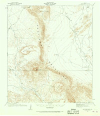
1917 Map of Santiago Peak
USGS Topo · Published 1968About this map
Santiago Peak anchors this 1917 survey of the West Texas landscape, showing a region defined by isolated cattle operations and seasonal watercourses. The map documents the early 20th-century ranching footprint in Brewster County, identifying family-named sites such as Buttrill Ranch, Schuler Ranch, and the Combs Cattle Co Ranch. These outposts are linked by rudimentary tracks leading toward distant hubs like Marathon and Terlingua. The topographic detail reveals a complex network of drainage systems, including Chalk Draw, Calamity Creek, and Maravillas Creek, which carve through the high elevations of the Santiago Mountains and Cochran Mountains. The prominence of Black Mtn and the flat-topped E Mesa illustrate the dramatic vertical relief that dictated the movement of livestock and travelers through this arid territory before modern infrastructure arrived.
Find a feature on this map
21 named features on this map. Tap any name to fly to it.
Don’t see what you’re looking for? This feature index may not catch every label — zoom into the map to look around manually.
Map Details
Editions of this 1917 Santiago Peak Map
3 editions found
Other maps of this area

1895 · Alpine
USGS Topo · 1:125,000

1917 · Agua Fria
USGS Topo · 1:62,500

1917 · Santiago Peak
USGS Topo · 1:62,500

1917 · Bone Spring
USGS Topo · 1:62,500

1917 · Buck Hill
USGS Topo · 1:62,500

1917 · Hood Spring
USGS Topo · 1:62,500

1918 · Bone Spring
USGS Topo · 1:125,000

1918 · Hood Spring
USGS Topo · 1:62,500

1918 · Buck Hill
USGS Topo · 1:62,500

1918 · Santiago Peak
USGS Topo · 1:62,500