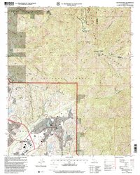
1997 Map of Santiago Peak
USGS Topo · Published 2000About this map
The Santa Ana Mountains dominate this landscape, rising to the prominent heights of Santiago Peak and Modjeska Peak. In the late 1990s, this area reflects a complex transition from protected forest lands to suburban expansion. The western slopes are dotted with spiritual and educational retreats, including the Ramakrishna Monastery and Saint Michaels College Preparatory School. Much of the rugged terrain is encompassed by the Cleveland National Forest, where a network of historic routes like the Main Divide Road, Harding Road, and the Holy Jim Trail provide access to the backcountry.
Find a feature on this map
49 named features on this map. Tap any name to fly to it.
Don’t see what you’re looking for? This feature index may not catch every label — zoom into the map to look around manually.
Map Details
Editions of this 1997 Santiago Peak Map
This is the sole edition of this map. No revisions or reprints were ever made.
Other maps of this area

1901 · Southern California Sheet No. 1
USGS Topo · 1:250,000

1901 · Elsinore
USGS Topo · 1:125,000

1901 · Riverside
USGS Topo · 1:62,500

1902 · Corona
USGS Topo · 1:125,000

1904 · Southern California Sheet No. 1
USGS Topo · 1:250,000

1935 · El Toro
USGS Topo · 1:31,680

1942 · Lake Elsinore
USGS Topo · 1:62,500

1942 · Santiago Peak
USGS Topo · 1:62,500

1942 · Corona
USGS Topo · 1:62,500

1942 · Riverside
USGS Topo · 1:62,500
Featured Places
- Mission Viejo, CA
- Lake Forest, CA
- Rancho Santa Margarita, CA
- Portola Hills, Lake Forest
- Canyon Crest, Mission Viejo