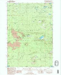
1988 Map of Santiam Junction
USGS Topo · Published 1988About this map
Lava flows dominate the western landscape of this mid-century survey, illustrating a geologically active corridor where modern infrastructure meets the volcanic past. The confluence at Santiam Junction serves as the primary hub for transportation, supporting both a local Landing Strip and nearby Cinder Pits. To the east, the terrain transitions into the high wilderness of the Willamette National Forest and Mt Jefferson Wilderness, characterized by a dense network of high-altitude water bodies such as Duffy Lake and Santiam Lake. The map reveals the area's mid-century recreational development, featuring the Ski Lifts at Hoodoo Butte and several campgrounds. Notable landmarks like Sawyers Caves and Sand Mountain provide specific points of interest for those studying the intersection of natural volcanic features and the developing tourism and resource extraction industries of the Cascades.
Find a feature on this map
49 named features on this map. Tap any name to fly to it.
Don’t see what you’re looking for? This feature index may not catch every label — zoom into the map to look around manually.
Map Details
Editions of this 1988 Santiam Junction Map
2 editions found
Other maps of this area

1927 · Mt. Jefferson
USGS Topo · 1:125,000

1929 · Mill City
USGS Topo · 1:125,000

1929 · Three Sisters
USGS Topo · 1:125,000

1930 · Mt. Jefferson
USGS Topo · 1:125,000

1932 · Three Sisters
USGS Topo · 1:125,000

1934 · Mc Kenzie Bridge
USGS Topo · 1:96,000

1940 · Mc Kenzie Bridge
USGS Topo · 1:125,000

1953 · Salem
USGS Topo · 1:250,000

1954 · Salem
USGS Topo · 1:250,000

1955 · Echo Mountain
USGS Topo · 1:62,500