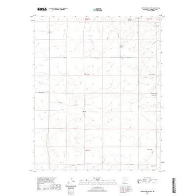
2020 Map of Santo Nino Canyon
USGS Topo · Published 2020About this map
Santo Niño Canyon and the surrounding high desert of Torrance County are defined by a complex network of drainage systems and isolated water sources. This 2020 landscape reveals the essential role of artificial catchments like Alvas Tank and Joselino Tank in an arid environment. The terrain is marked by significant elevation changes, from the heights of Lobo Hill down into the deep incisions of Carrizo Canyon and Viejo Canyon. The presence of Bigs Bee Ranch Rd and numerous county roads like Co RD c048 suggests a region primarily dedicated to large-scale ranching. Local topography is further distinguished by Cañoncito de Milpa and Red Canyon, illustrating the varied geological formations of the New Mexico interior. Water movement is seasonal and critical, traced through features such as Pintada Arroyo, Amarillo Draw, and Lobo Draw.
Find a feature on this map
29 named features on this map. Tap any name to fly to it.
Don’t see what you’re looking for? This feature index may not catch every label — zoom into the map to look around manually.
Map Details
Editions of this 2020 Santo Nino Canyon Map
This is the sole edition of this map. No revisions or reprints were ever made.
Other maps of this area

1954 · Fort Sumner
USGS Topo · 1:250,000

1958 · Fort Sumner
USGS Topo · 1:250,000
1978 · Waller Ranch
USGS Topo · 1:24,000
1978 · Milagro Spring
USGS Topo · 1:24,000

1978 · North Lucy
USGS Topo · 1:24,000

1978 · Santa Barbara Lake
USGS Topo · 1:24,000

1978 · Santo Nino Canyon
USGS Topo · 1:24,000

1978 · Encino
USGS Topo · 1:24,000

1978 · Negra
USGS Topo · 1:24,000
1978 · Palma
USGS Topo · 1:24,000