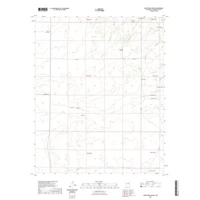
2023 Map of Santo Nino Canyon
USGS Topo · Published 2023About this map
Santo Niño Canyon and the surrounding high desert of Torrance County are defined by an intricate network of drainage systems and vital water catchments. This 2023 survey by the U.S. Geological Survey illustrates a landscape where seasonal water flow has carved significant features like Viejo Canyon, Carrizo Canyon, and Gato Canyon into the terrain. The presence of several named water tanks, such as Alvas Tank and Cañoncito Tank, indicates the ongoing importance of water management for local ranching operations in this arid environment. Transportation through this part of New Mexico is facilitated by a grid of county roads and private routes like Bigs Bee Ranch Rd, which cross varied elevations including the prominent Lobo Hill. The map also traces the distinct paths of Lobo Draw and Amarillo Draw, highlighting the natural runoff patterns that have shaped this portion of the Estancia Basin periphery.
Find a feature on this map
30 named features on this map. Tap any name to fly to it.
Don’t see what you’re looking for? This feature index may not catch every label — zoom into the map to look around manually.
Map Details
Editions of this 2023 Santo Nino Canyon Map
This is the sole edition of this map. No revisions or reprints were ever made.
Other maps of this area

1954 · Fort Sumner
USGS Topo · 1:250,000

1958 · Fort Sumner
USGS Topo · 1:250,000
1978 · Waller Ranch
USGS Topo · 1:24,000
1978 · Milagro Spring
USGS Topo · 1:24,000

1978 · North Lucy
USGS Topo · 1:24,000

1978 · Santa Barbara Lake
USGS Topo · 1:24,000

1978 · Santo Nino Canyon
USGS Topo · 1:24,000

1978 · Encino
USGS Topo · 1:24,000

1978 · Negra
USGS Topo · 1:24,000
1978 · Palma
USGS Topo · 1:24,000