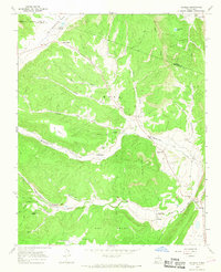
1965 Map of Sapello
USGS Topo · Published 1968About this map
The land division between the Mora Grant and the Las Vegas Grant shapes this mid-1960s landscape, where small agricultural settlements are tucked into the valleys of the Sangre de Cristo foothills. The village of Sapello sits at the confluence of the Sapello River and Manuelitas Creek, serving as a focal point for the surrounding rural communities of Las Tusas and San Ignacio. Local genealogy is well-documented through several family and community landmarks, including the San Ignacio Cem, Soledad Cem, and the Brother of Jesus Mission.
Find a feature on this map
36 named features on this map. Tap any name to fly to it.
Don’t see what you’re looking for? This feature index may not catch every label — zoom into the map to look around manually.
Map Details
Editions of this 1965 Sapello Map
2 editions found
Other maps of this area

1889 · Las Vegas
USGS Topo · 1:125,000

1891 · Las Vegas
USGS Topo · 1:125,000

1893 · Las Vegas
USGS Topo · 1:125,000

1954 · Santa Fe
USGS Topo · 1:250,000

1958 · Santa Fe
USGS Topo · 1:250,000

1961 · El Porvenir
USGS Topo · 1:24,000

1961 · Montezuma
USGS Topo · 1:24,000

1963 · Lake Isabel
USGS Topo · 1:24,000

1963 · Rainsville
USGS Topo · 1:24,000
1963 · Las Vegas NW
USGS Topo · 1:24,000