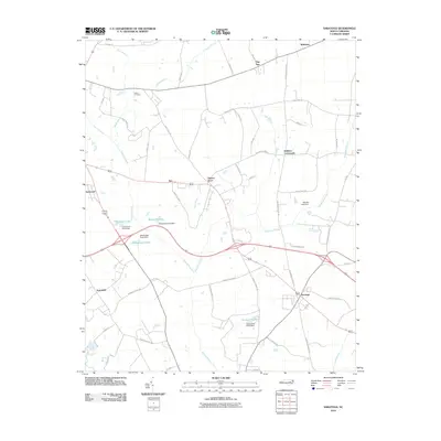
2010 Map of Saratoga
USGS Topo · Published 2010About this map
Saratoga and its surrounding agricultural crossroads anchor this eastern North Carolina landscape, where the drainage patterns of the Toisnot Swamp and Whiteoak Swamp have long dictated the placement of roads and farmsteads. The area is characterized by numerous small impoundments, including Edmunson Pond, Woodards Pond, and Archie-Ellis Pond, each marked with its respective dam. These water features, alongside Cattail Branch and Mill Branch, provide a detailed look at the local hydrology that supported the region's rural development. Small community hubs such as Wilbanks, Holdens Crossroads, and Drivers Store are scattered across the quadrangle, connected by a network of local routes like Tartts Mill Rd and Gardners School Rd. For those tracing local lineage, the Toisnot Cemetery remains a significant landmark within this traditional farming district.
Find a feature on this map
57 named features on this map. Tap any name to fly to it.
Don’t see what you’re looking for? This feature index may not catch every label — zoom into the map to look around manually.
Map Details
Editions of this 2010 Saratoga Map
This is the sole edition of this map. No revisions or reprints were ever made.
Other maps of this area

1902 · Rocky Mount
USGS Topo · 1:62,500

1902 · Tarboro
USGS Topo · 1:62,500

1903 · Tarboro
USGS Topo · 1:62,500

1904 · Falkland
USGS Topo · 1:62,500

1904 · Rocky Mount
USGS Topo · 1:62,500

1904 · Wilson
USGS Topo · 1:62,500

1953 · Rocky Mount
USGS Topo · 1:250,000

1954 · Rocky Mount
USGS Topo · 1:250,000
1977 · Winstead Crossroads
USGS Topo · 1:24,000
1977 · Elm City
USGS Topo · 1:24,000