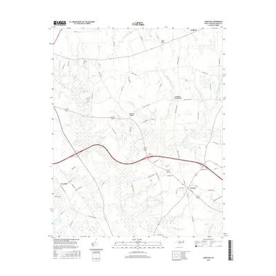
2016 Map of Saratoga
USGS Topo · Published 2016About this map
Saratoga anchors the southeastern corner of this Wilson County landscape, where the agricultural patterns of eastern North Carolina remain deeply inscribed on the land. The topography is defined by an extensive network of drainage systems, including the broad Toisnot Swamp and Whiteoak Swamp, which meander through the low-lying reaches. These watercourses are punctuated by several significant impoundments such as Harrells Lake, Archie Ellis Pond, and Woodards Pond. Small communities and named junctions like Holdens Crossroads, Wilbanks, and Drivers Store serve as local focal points along the rural road network. Genealogists may find interest in the Toisnot Cem located in the northern portion of the quadrangle. The map captures a transition between traditional agrarian tracts and localized development, illustrating how historical property lines and natural water boundaries continue to dictate the placement of homes and businesses in settlements like Evansdale and Pine Tree.
Find a feature on this map
71 named features on this map. Tap any name to fly to it.
Don’t see what you’re looking for? This feature index may not catch every label — zoom into the map to look around manually.
Map Details
Editions of this 2016 Saratoga Map
This is the sole edition of this map. No revisions or reprints were ever made.
Other maps of this area

1902 · Rocky Mount
USGS Topo · 1:62,500

1902 · Tarboro
USGS Topo · 1:62,500

1903 · Tarboro
USGS Topo · 1:62,500

1904 · Falkland
USGS Topo · 1:62,500

1904 · Rocky Mount
USGS Topo · 1:62,500

1904 · Wilson
USGS Topo · 1:62,500

1953 · Rocky Mount
USGS Topo · 1:250,000

1954 · Rocky Mount
USGS Topo · 1:250,000
1977 · Winstead Crossroads
USGS Topo · 1:24,000
1977 · Elm City
USGS Topo · 1:24,000