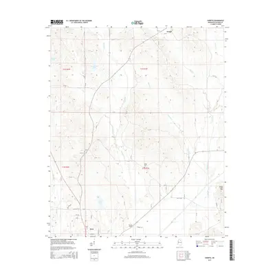
2015 Map of Sarepta
USGS Topo · Published 2015About this map
Sarepta and the northern reaches of Bruce anchor this Calhoun County landscape, where the terrain transitions from the low-lying basin of Cowpen Cr to the modest elevation of Johnny Main Mtn. The 2015 survey reveals a pattern of rural settlement defined by a network of county roads like Rocky Mount Rd and Sam Nations Rd, connecting scattered residences and local infrastructure. Genealogists will find several burial grounds across the area, including Mount Moriah Cem, Antioch Cem, and Bruce Cem. The presence of Hasting Airpark near the southern boundary suggests the modernization of this agricultural corridor. Water features are numerous, ranging from the sizeable Gullicks Lake to the smaller Edwards Lake and Moorehead Lakes, which punctuate the woodlands and fields of the Skuna River watershed.
Find a feature on this map
36 named features on this map. Tap any name to fly to it.
Don’t see what you’re looking for? This feature index may not catch every label — zoom into the map to look around manually.
Map Details
Editions of this 2015 Sarepta Map
This is the sole edition of this map. No revisions or reprints were ever made.
Other maps of this area

1953 · West Point
USGS Topo · 1:250,000

1954 · Pittsboro
USGS Topo · 1:62,500

1956 · Tupelo
USGS Topo · 1:250,000

1958 · Tupelo
USGS Topo · 1:250,000

1958 · West Point
USGS Topo · 1:250,000

1963 · West Point
USGS Topo · 1:250,000

1972 · Paris
USGS Topo · 1:24,000

1972 · Robbs
USGS Topo · 1:24,000
1972 · Banner
USGS Topo · 1:24,000

1972 · Vardaman
USGS Topo · 1:24,000