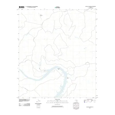
2010 Map of Satan Canyon
USGS Topo · Published 2010About this map
Devils River dominates the southern portion of this landscape, carving a wide path through the arid terrain of Val Verde County. The river makes a dramatic sweep at Slaughter Bend, where the topography shifts from open ranch land to the stark edges of Indian Cliffs. This region is characterized by deep drainage systems, most notably the namesake Satan Canyon and its tributaries, Big Satan Creek and Little Satan Creek.
Find a feature on this map
13 named features on this map. Tap any name to fly to it.
Don’t see what you’re looking for? This feature index may not catch every label — zoom into the map to look around manually.
Map Details
Editions of this 2010 Satan Canyon Map
This is the sole edition of this map. No revisions or reprints were ever made.
Other maps of this area

1941 · Feely
USGS Topo · 1:62,500

1944 · Dry Devil
USGS Topo · 1:62,500

1944 · Devils Lake
USGS Topo · 1:62,500

1944 · Baker Crossing
USGS Topo · 1:62,500

1958 · Del Rio
USGS Topo · 1:250,000

1964 · Del Rio
USGS Topo · 1:250,000

1972 · California Creek
USGS Topo · 1:24,000

1972 · Miers Ranch
USGS Topo · 1:24,000

1972 · Rough Canyon SE
USGS Topo · 1:24,000
1972 · Satan Canyon
USGS Topo · 1:24,000