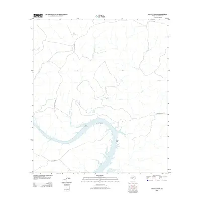
2012 Map of Satan Canyon
USGS Topo · Published 2012About this map
The Devils River dominates this arid Val Verde County landscape as it carves through Slaughter Bend and past the steep Indian Cliffs. This part of Southwest Texas is defined by its dramatic hydrology, where numerous freshwater sources like Slaughter Bend Springs, Indian Springs, and Lowry Springs emerge along the riverbanks. The terrain is deeply incised by a network of seasonal drainages, including the ominously named Satan Canyon, Big Satan Cr, and Little Satan Cr. Transport and access are primarily provided by a system of private ranch roads, such as Wardlaw Ranch Rd and Indian Head Ranch Rd, which serve the expansive holdings in this area. A small landing strip, the Devil's River Ranch Airport, provides a rare point of modern infrastructure in an otherwise remote environment characterized by limestone bluffs and the winding course of the river.
Find a feature on this map
15 named features on this map. Tap any name to fly to it.
Don’t see what you’re looking for? This feature index may not catch every label — zoom into the map to look around manually.
Map Details
Editions of this 2012 Satan Canyon Map
This is the sole edition of this map. No revisions or reprints were ever made.
Other maps of this area

1941 · Feely
USGS Topo · 1:62,500

1944 · Dry Devil
USGS Topo · 1:62,500

1944 · Devils Lake
USGS Topo · 1:62,500

1944 · Baker Crossing
USGS Topo · 1:62,500

1958 · Del Rio
USGS Topo · 1:250,000

1964 · Del Rio
USGS Topo · 1:250,000

1972 · California Creek
USGS Topo · 1:24,000

1972 · Miers Ranch
USGS Topo · 1:24,000

1972 · Rough Canyon SE
USGS Topo · 1:24,000
1972 · Satan Canyon
USGS Topo · 1:24,000