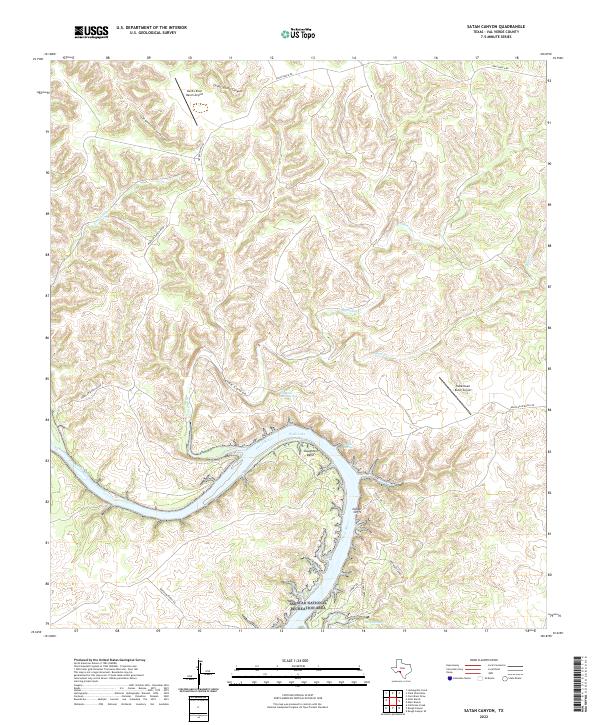
2022 Map of Satan Canyon
USGS Topo · Published 2022About this map
Devils River winds through a deeply incised landscape in this modern survey of Val Verde County, forming the prominent Slaughter Bend before flowing south into the Amistad National Recreation Area. The terrain is defined by a dense network of drainages including Satan Canyon, Big Satan Cr, and Little Satan Cr, which feed into the main river channel. This arid ranching country is punctuated by several water sources like Slaughter Bend Springs, Indian Springs, and the secluded Walk Lake. Local infrastructure is sparse, characterized by private landing strips such as Devil's River Ranch Airport and Indianhead Ranch Airport, along with a web of named ranch roads. The presence of Indian Cliffs and Lowry Springs further illustrates the complex topography of this rugged corner of Southwest Texas.
Find a feature on this map
25 named features on this map. Tap any name to fly to it.
Don’t see what you’re looking for? This feature index may not catch every label — zoom into the map to look around manually.
Map Details
Editions of this 2022 Satan Canyon Map
This is the sole edition of this map. No revisions or reprints were ever made.
Other maps of this area

1941 · Feely
USGS Topo · 1:62,500

1944 · Dry Devil
USGS Topo · 1:62,500

1944 · Devils Lake
USGS Topo · 1:62,500

1944 · Baker Crossing
USGS Topo · 1:62,500

1958 · Del Rio
USGS Topo · 1:250,000

1964 · Del Rio
USGS Topo · 1:250,000

1972 · California Creek
USGS Topo · 1:24,000

1972 · Miers Ranch
USGS Topo · 1:24,000

1972 · Rough Canyon SE
USGS Topo · 1:24,000
1972 · Satan Canyon
USGS Topo · 1:24,000