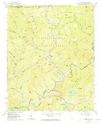
1961 Map of Satolah
USGS Topo · Published 1972About this map
The Chattooga River defines the tri-state boundary where Georgia, South Carolina, and North Carolina meet in this 1961 field-checked survey. The settlement of Satolah serves as a central point for the remote mountain communities, characterized by a network of family-named landmarks and gaps. Small timber and agricultural interests are evident through features like Talley Mill Road and Stakey Mill Road, while religious and community life is anchored at Macedonia Church and Mt Pleasant Church.
Find a feature on this map
139 named features on this map. Tap any name to fly to it.
Don’t see what you’re looking for? This feature index may not catch every label — zoom into the map to look around manually.
Map Details
Editions of this 1961 Satolah Map
3 editions found
Other maps of this area

1886 · Walhalla
USGS Topo · 1:125,000

1891 · Cowee
USGS Topo · 1:125,000

1892 · Walhalla
USGS Topo · 1:125,000

1896 · Walhalla
USGS Topo · 1:125,000

1897 · Cowee
USGS Topo · 1:125,000

1907 · Cowee
USGS Topo · 1:125,000

1935 · Cashiers
USGS Topo · 1:24,000

1935 · Scaly
USGS Topo · 1:24,000

1935 · Rabun Bald
USGS Topo · 1:24,000
1935 · Highlands
USGS Topo · 1:24,000