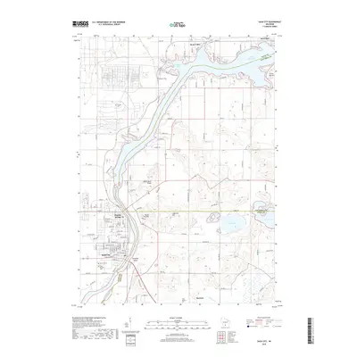
2018 Map of Sauk City
USGS Topo · Published 2018About this map
Prairie du Sac and Sauk City anchor this landscape along the western bank of the Wisconsin River, where the river begins its southward turn past Mosquito Island. This 2018 survey illustrates the relationship between these Twin Cities of the Wisconsin River valley and the surrounding glacial terrain, including prominent elevations like Black Hawk Ridge, Sugarloaf Hill, and Round Top Hill. To the north, the river expands into Lake Wisconsin and Wiegands Bay near the village of Merrimac, while the southeastern corner is defined by the wetlands surrounding Fish Lake and Mud Lake. Local history and genealogy are well-represented by numerous burial grounds, including the Saint Aloysius and Saint Norbert's cemeteries. The map details the transition from the concentrated grid of the river towns to the rural reaches of Roxbury, where Roxbury Cr winds through the valley floor.
Find a feature on this map
108 named features on this map. Tap any name to fly to it.
Don’t see what you’re looking for? This feature index may not catch every label — zoom into the map to look around manually.
Map Details
Editions of this 2018 Sauk City Map
This is the sole edition of this map. No revisions or reprints were ever made.
Other maps of this area

1895 · Baraboo
USGS Topo · 1:62,500

1901 · Denzer
USGS Topo · 1:62,500

1907 · Cross Plains
USGS Topo · 1:62,500

1908 · Baraboo
USGS Topo · 1:62,500

1909 · Cross Plains
USGS Topo · 1:62,500

1920 · Blue Mounds
USGS Topo · 1:62,500

1922 · Blue Mounds
USGS Topo · 1:62,500

1957 · Madison
USGS Topo · 1:250,000

1958 · North Freedom
USGS Topo · 1:62,500

1959 · Baraboo
USGS Topo · 1:62,500