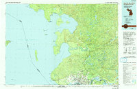
1985 Map of Sault Ste. Marie North
USGS Topo · Published 1991About this map
The international border between Ontario and Michigan bisects the deep waters of Whitefish Bay and Lake Superior on this mid-1980s survey. The twin cities of Sault Ste Marie serve as the focal point where the St Marys River connects the Great Lakes, featuring a dense network of neighborhoods such as Brookfield, Steelton, and Bayview. To the north, the Canadian landscape is defined by the Algoma Central Railway winding through the highlands toward Searchmont and Wabos, passing numerous lakes like Ogidaki Lake and Achigan Lake.
Find a feature on this map
116 named features on this map. Tap any name to fly to it.
Don’t see what you’re looking for? This feature index may not catch every label — zoom into the map to look around manually.
Map Details
Editions of this 1985 Sault Ste. Marie North Map
2 editions found
Other maps of this area

1913 · Sault Sainte Marie
USGS Topo · 1:62,500

1919 · Neebish
USGS Topo · 1:62,500

1941 · Neebish
USGS Topo · 1:63,360

1941 · Sault Sainte Marie
USGS Topo · 1:63,360

1941 · Strongs
USGS Topo · 1:63,360

1941 · Brimley
USGS Topo · 1:63,360

1951 · Vermilion SE
USGS Topo · 1:24,000

1951 · Shallows
USGS Topo · 1:24,000

1951 · Shelldrake
USGS Topo · 1:24,000

1951 · McNearney Lake
USGS Topo · 1:24,000