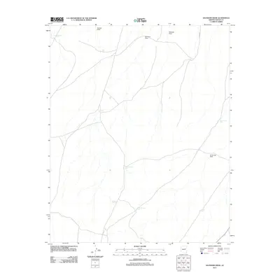
2011 Map of Saunders Draw
USGS Topo · Published 2011About this map
Saunders Draw and its network of ephemeral watercourses define this high-desert landscape in Navajo County. The area is characterized by a sophisticated system of cattle tanks and water management features essential for ranching in the arid Arizona interior. Named drainages such as Marshall Draw, Randall Draw, and Porter Tank Draw feed into these basins, highlighting the topographic reliance on seasonal runoff. Human infrastructure is subtly etched into the terrain, primarily represented by utility corridors like the Lower Powerline Tank and Gas Line Tank, alongside local transport routes such as I X Ranch Rd. This map captures a snapshot of traditional land use where water sources like Rattlesnake Tank and Midway Tank serve as the primary landmarks across the open range.
Find a feature on this map
13 named features on this map. Tap any name to fly to it.
Don’t see what you’re looking for? This feature index may not catch every label — zoom into the map to look around manually.
Map Details
Editions of this 2011 Saunders Draw Map
This is the sole edition of this map. No revisions or reprints were ever made.
Other maps of this area

1886 · Holbrook
USGS Topo · 1:250,000

1893 · Holbrook
USGS Topo · 1:250,000

1954 · Holbrook
USGS Topo · 1:250,000

1955 · St. Joseph 2 SE
USGS Topo · 1:24,000
1955 · St. Joseph 2 NW
USGS Topo · 1:24,000

1955 · St. Joseph 1 NW
USGS Topo · 1:24,000
1955 · St. Joseph 2 NE
USGS Topo · 1:24,000

1955 · Joseph City
USGS Topo · 1:62,500
1955 · Holbrook
USGS Topo · 1:62,500

1957 · Holbrook
USGS Topo · 1:250,000