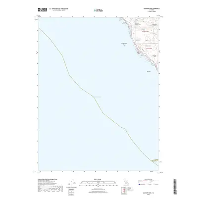
2018 Map of Saunders Reef
USGS Topo · Published 2018About this map
Saunders Reef and the dramatic coastline of Mendocino County define this 2018 coastal study. The map documents the intricate series of gulches and points where the land meets the Pacific Ocean, including the distinctive Bowling Ball Beach and Iversen Point. This modern survey traces the rugged drainage patterns of Galloway Cr and the complex of Schooner Gulch with its numerous tributaries.
Find a feature on this map
20 named features on this map. Tap any name to fly to it.
Don’t see what you’re looking for? This feature index may not catch every label — zoom into the map to look around manually.
Map Details
Editions of this 2018 Saunders Reef Map
This is the sole edition of this map. No revisions or reprints were ever made.
Other maps of this area

1943 · Point Arena
USGS Topo · 1:62,500

1947 · Santa Rosa
USGS Topo · 1:250,000

1949 · Santa Rosa
USGS Topo · 1:250,000

1958 · Santa Rosa
USGS Topo · 1:250,000

1960 · Saunders Reef
USGS Topo · 1:24,000
1960 · Gualala
USGS Topo · 1:24,000
1960 · Point Arena
USGS Topo · 1:62,500
1960 · Point Arena
USGS Topo · 1:24,000
1962 · Santa Rosa
USGS Topo · 1:250,000
1964 · Santa Rosa
USGS Topo · 1:250,000