1960 Map of Gualala
USGS Topo · Published 1961About this map
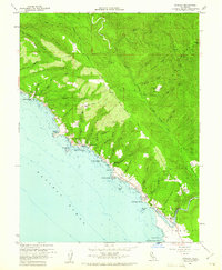
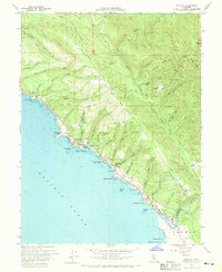
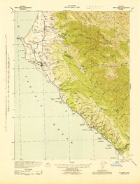
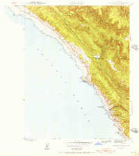
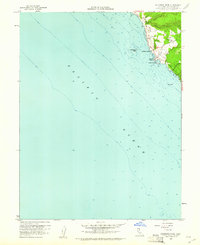
Gualala stands at the southernmost edge of the Mendocino coast in this 1960 survey, marking a transition defined by timber and maritime history. The town site is anchored by a Lumber Mill and several structures at the mouth of the Gualala River, where the Mendocino Co Sonoma Co line crosses the water. Along the bluff-lined shore, numerous small landings such as Bourns Landing, Collins Landing, and Steens Landing suggest the legacy of the doghole ports that once served the redwood trade. Inland, the landscape is deeply etched by gulches and creeks, including China Gulch and Schooner Gulch, which drain from the timbered heights of Gualala Mtn. Scattered rural features like Brooks Field, the Seaside Sch, and Bourns Cem provide evidence of early family settlement and community life. The winding paths of Iversen Road and Signal Opening Road link these isolated outposts across the high ridges above Anchor Bay.
Find a feature on this map
53 named features on this map. Tap any name to fly to it.
Don’t see what you’re looking for? This feature index may not catch every label — zoom into the map to look around manually.
Map Details
Editions of this 1960 Gualala Map
3 editions found

Other maps of this area

1921 · Plantation
USGS Topo · 1:62,500
1943 · Point Arena
USGS Topo · 1:62,500
1943 · Stewarts Point
USGS Topo · 1:24,000

1943 · Ornbaun
USGS Topo · 1:62,500

1944 · Stewarts Point
USGS Topo · 1:31,680

1944 · Ornbaun
USGS Topo · 1:62,500

1947 · Santa Rosa
USGS Topo · 1:250,000

1949 · Santa Rosa
USGS Topo · 1:250,000

1958 · Santa Rosa
USGS Topo · 1:250,000
1960 · Saunders Reef
USGS Topo · 1:24,000