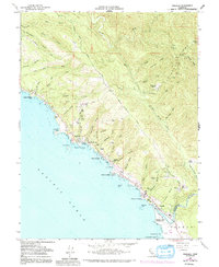
1960 Map of Gualala
USGS Topo · Published 1991About this map
Signal Ridge and the South Fork Garcia River define the steep, gulch-cut topography of this coastal stretch where Mendocino and Sonoma counties meet. The coastline is marked by historic maritime points like Steens Landing, Havens Anchorage, and Bourns Landing, reflecting an era when small vessels were the primary link for the local timber economy. Near the mouth of the Gualala River, the settlement of Gualala serves as a focal point, featuring a Lumber Mill, a Trailer Park, and the nearby Gualala Point County Park. Inland, the landscape is a network of ridges and family-named landmarks such as Wildwood Ranch and Brooks Field. Small-scale heritage is preserved in sites like the Bourn Cem and the residential clusters at Anchor Bay, all set against a backdrop of deep drainage features like Robinson Gulch and St Orres Creek.
Find a feature on this map
67 named features on this map. Tap any name to fly to it.
Don’t see what you’re looking for? This feature index may not catch every label — zoom into the map to look around manually.
Map Details
Editions of this 1960 Gualala Map
3 editions found
Other maps of this area

1921 · Plantation
USGS Topo · 1:62,500

1943 · Point Arena
USGS Topo · 1:62,500

1943 · Stewarts Point
USGS Topo · 1:24,000

1943 · Ornbaun
USGS Topo · 1:62,500

1944 · Stewarts Point
USGS Topo · 1:31,680

1944 · Ornbaun
USGS Topo · 1:62,500

1947 · Santa Rosa
USGS Topo · 1:250,000

1949 · Santa Rosa
USGS Topo · 1:250,000

1958 · Santa Rosa
USGS Topo · 1:250,000

1960 · Saunders Reef
USGS Topo · 1:24,000