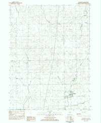
1983 Map of Saunemin
USGS Topo · Published 1983About this map
Saunemin serves as the primary hub of this Livingston County landscape, situated along the Norfolk and Western rail line and bounded by agricultural townships. The village is anchored by Sunny Slope Cem to its south, while the surrounding prairie is dotted with smaller points of interest including Scovel to the northwest and the settlement of Loretto further north in Union township. Waterways like Gooseberry Creek and Fivemile Creek cut through the gridded road network, defining the drainage patterns of this central Illinois terrain.
Find a feature on this map
16 named features on this map. Tap any name to fly to it.
Don’t see what you’re looking for? This feature index may not catch every label — zoom into the map to look around manually.
Map Details
Editions of this 1983 Saunemin Map
This is the sole edition of this map. No revisions or reprints were ever made.
Other maps of this area

1935 · Pontiac
USGS Topo · 1:62,500

1939 · Pontiac
USGS Topo · 1:62,500

1947 · Cullom
USGS Topo · 1:62,500

1948 · Dwight
USGS Topo · 1:62,500

1949 · Cullom
USGS Topo · 1:62,500

1950 · Dwight
USGS Topo · 1:62,500

1958 · Odell
USGS Topo · 1:62,500

1958 · Aurora
USGS Topo · 1:250,000

1958 · Peoria
USGS Topo · 1:250,000

1961 · Aurora
USGS Topo · 1:250,000