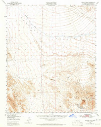
1950 Map of Savahia Peak
USGS Topo · Published 1965About this map
Whipple Mountains and the Turtle Mts dominate this mid-century survey of the California desert, where the landscape is defined by drainage patterns and hard-rock mining claims. The expansive Chemehuevi Valley occupies the northern half of the sheet, bisected by the long, winding Chemehuevi Wash. Evidence of early habitation or prospecting efforts appears as Ruins and scattered Prospects throughout the basins.
Find a feature on this map
24 named features on this map. Tap any name to fly to it.
Don’t see what you’re looking for? This feature index may not catch every label — zoom into the map to look around manually.
Map Details
Editions of this 1950 Savahia Peak Map
2 editions found

Other maps of this area

1903 · Needles
USGS Topo · 1:125,000

1904 · Needles Special
USGS Topo · 1:125,000

1911 · Parker
USGS Topo · 1:125,000

1943 · Center Hills
USGS Topo · 1:62,500

1943 · Topock
USGS Topo · 1:62,500

1943 · Whipple Mts.
USGS Topo · 1:62,500

1943 · Parker
USGS Topo · 1:62,500

1943 · Turtle Mts.
USGS Topo · 1:62,500

1943 · Vidal
USGS Topo · 1:62,500

1949 · Parker
USGS Topo · 1:62,500