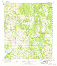
1955 Map of Savannah
USGS Topo · Published 1968About this map
The southern Mississippi piney woods and coastal plains dominate this mid-century landscape, centered on the De Soto National Forest and the winding course of the Wolf River. This survey captures a rural network of small timber-and-farming communities like Savannah, Necaise, and Lizana before modern development patterns fully shifted. The map is particularly rich for genealogical research, documenting numerous country churches and burial grounds such as White Cypress Ch, Shiloh Ch, and the Sand Hill Cem.
Find a feature on this map
53 named features on this map. Tap any name to fly to it.
Don’t see what you’re looking for? This feature index may not catch every label — zoom into the map to look around manually.
Map Details
Editions of this 1955 Savannah Map
Other maps of this area

1914 · Nicholson
USGS Topo · 1:62,500

1921 · Nicholson
USGS Topo · 1:62,500

1947 · Wiggins
USGS Topo · 1:62,500

1949 · Wiggins
USGS Topo · 1:62,500

1953 · Mobile
USGS Topo · 1:250,000

1954 · McHenry
USGS Topo · 1:62,500

1955 · Savannah
USGS Topo · 1:62,500

1956 · Vidalia
USGS Topo · 1:24,000

1956 · Gulfport NW
USGS Topo · 1:24,000

1957 · Mobile
USGS Topo · 1:250,000