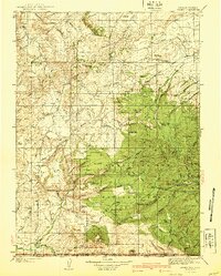
1940 Map of Savery
USGS Topo · Published 1940About this map
Savery and the Slater community anchor the southern edge of this 1940 survey, where the Snake River and Little Snake River meet at the Wyoming-Colorado border. This high-altitude landscape is dominated by the Continental Divide, which snakes through the Medicine Bow National Forest. The map documents a period when rural education and forest management were critical to local life, evidenced by the presence of Ketchum Sch, Browns Hill Sch, and several remote outposts like Jack Creek Ranger Sta and Rambler Ranger Sta. Significant topographical landmarks such as Green Ridge and Brown s Hill provide a window into the cattle-ranching and timber heritage of Carbon County. Water sources like Savery Creek and Sage Creek Basin show the complex drainage patterns of the high country, while the inclusion of Tullis further north marks a vanished footprint of earlier settlement.
Find a feature on this map
62 named features on this map. Tap any name to fly to it.
Don’t see what you’re looking for? This feature index may not catch every label — zoom into the map to look around manually.
Map Details
Editions of this 1940 Savery Map
2 editions found
Other maps of this area

1893 · Fort Steele
USGS Topo · 1:125,000

1911 · Hahns Peak
USGS Topo · 1:125,000

1913 · Hahns Peak
USGS Topo · 1:125,000

1916 · Craig
USGS Topo · 1:125,000

1932 · Savery
USGS Topo · 1:96,000

1939 · Saratoga
USGS Topo · 1:125,000

1940 · Savery
USGS Topo · 1:125,000

1954 · Rawlins
USGS Topo · 1:250,000

1954 · Craig
USGS Topo · 1:250,000

1955 · Overland Crossing
USGS Topo · 1:24,000