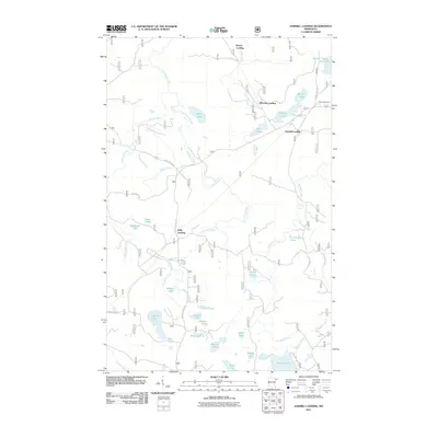
2011 Map of Sawbill Landing
USGS Topo · Published 2011About this map
Sawbill Landing and a series of remote outposts define this northern Minnesota landscape, where the road network is dictated by the complex waterways of the Arrowhead region. The map reveals a cluster of landings along the rivers and lakes, including Wheeler Landing and Kelly Landing, which historically served as vital access points for timber and transport. The Dumbbell River and Arrowhead Creek systems anchor the geography, connecting dozens of uniquely named water bodies such as Weapon Lake, Redskin Lake, and Shoofly Lake.
Find a feature on this map
41 named features on this map. Tap any name to fly to it.
Don’t see what you’re looking for? This feature index may not catch every label — zoom into the map to look around manually.
Map Details
Editions of this 2011 Sawbill Landing Map
This is the sole edition of this map. No revisions or reprints were ever made.
Other maps of this area

1954 · Two Harbors
USGS Topo · 1:250,000

1955 · Isabella
USGS Topo · 1:62,500

1955 · Cramer
USGS Topo · 1:62,500

1957 · Two Harbors
USGS Topo · 1:250,000

1958 · Two Harbors
USGS Topo · 1:250,000

1960 · Perent Lake
USGS Topo · 1:24,000

1964 · Two Harbors
USGS Topo · 1:250,000
1981 · Silver Island Lake
USGS Topo · 1:24,000
1981 · Isabella
USGS Topo · 1:24,000
1981 · Mitawan Lake
USGS Topo · 1:24,000