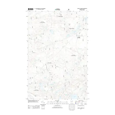
2013 Map of Sawbill Landing
USGS Topo · Published 2013About this map
Superior National Forest encompasses this section of northeastern Minnesota, where a network of forest routes and river systems defines the landscape. The region is characterized by numerous small settlements and camps, notably Sawbill Landing, Martin Landing, and Wheeler Landing, which serve as focal points for navigating the dense woods. The hydrography is particularly complex, featuring a series of interconnected water bodies such as Dumbbell Lake, Helen Lake, and the winding Dumbbell River. This 2013 survey illustrates the modern management of these timberlands, showing how Forest Rte 173 and Arrowhead Rd provide access to remote areas like Long Lake Camp and Kelly Landing. The map captures a high density of named water features, from the Little Isabella River to uniquely named ponds like Finn Pond and Doghouse Lake, reflecting the local heritage and recreational geography of the Arrowhead region.
Find a feature on this map
43 named features on this map. Tap any name to fly to it.
Don’t see what you’re looking for? This feature index may not catch every label — zoom into the map to look around manually.
Map Details
Editions of this 2013 Sawbill Landing Map
This is the sole edition of this map. No revisions or reprints were ever made.
Other maps of this area

1954 · Two Harbors
USGS Topo · 1:250,000

1955 · Isabella
USGS Topo · 1:62,500

1955 · Cramer
USGS Topo · 1:62,500

1957 · Two Harbors
USGS Topo · 1:250,000

1958 · Two Harbors
USGS Topo · 1:250,000

1960 · Perent Lake
USGS Topo · 1:24,000

1964 · Two Harbors
USGS Topo · 1:250,000
1981 · Silver Island Lake
USGS Topo · 1:24,000
1981 · Isabella
USGS Topo · 1:24,000
1981 · Mitawan Lake
USGS Topo · 1:24,000