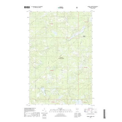
2019 Map of Sawbill Landing
USGS Topo · Published 2019About this map
Sawbill Landing sits within the dense woodlands of the Superior National Forest, serving as a central point for the remote water-and-rail infrastructure of Lake County. The landscape is defined by an extensive network of industrial and access routes, most notably the Dmir Grade, which speaks to the legacy of timber and ore transport in northern Minnesota. This 2019 survey documents a complex lacustrine environment where the Dumbell River and Bumbell River wind through a terrain saturated with small glacial lakes such as Helen Lake, Tomlinson Lake, and Eighteen Lake. Modern recreational use is represented by the Eighteen Lake Boat Access, while numerous forest service roads like Jackpine Spur T and Trappers Lake road provide a glimpse into the localized movement patterns required to navigate this wilderness area.
Find a feature on this map
57 named features on this map. Tap any name to fly to it.
Don’t see what you’re looking for? This feature index may not catch every label — zoom into the map to look around manually.
Map Details
Editions of this 2019 Sawbill Landing Map
This is the sole edition of this map. No revisions or reprints were ever made.
Other maps of this area

1954 · Two Harbors
USGS Topo · 1:250,000

1955 · Isabella
USGS Topo · 1:62,500

1955 · Cramer
USGS Topo · 1:62,500

1957 · Two Harbors
USGS Topo · 1:250,000

1958 · Two Harbors
USGS Topo · 1:250,000

1960 · Perent Lake
USGS Topo · 1:24,000

1964 · Two Harbors
USGS Topo · 1:250,000
1981 · Silver Island Lake
USGS Topo · 1:24,000
1981 · Isabella
USGS Topo · 1:24,000
1981 · Mitawan Lake
USGS Topo · 1:24,000