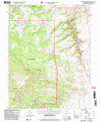
2001 Map of Sawtooth Mountain
USGS Topo · Published 2004About this map
Gunnison National Forest dominates this Saguache County landscape, where high-altitude drainages define the geography. The map reveals a history of extraction and early habitation, evidenced by the Los Ocho Mine in the northeast and numerous mining Prospects scattered across the ridges. The presence of Townsite Gulch and Homestead Gulch suggests a legacy of early mountain settlement and ranching long after the initial frontier period. A complex network of waterways, including Cochetopa Creek and Bead Creek, carves through the terrain, originating from high points like Sawtooth Mountain and Agency Peak. The Doyleville Cutoff serves as a primary transit route through this isolated high-country environment, connecting remote drainages to the larger regional infrastructure.
Find a feature on this map
28 named features on this map. Tap any name to fly to it.
Don’t see what you’re looking for? This feature index may not catch every label — zoom into the map to look around manually.
Map Details
Editions of this 2001 Sawtooth Mountain Map
This is the sole edition of this map. No revisions or reprints were ever made.
Other maps of this area

1954 · Iris NW
USGS Topo · 1:24,000

1956 · Montrose
USGS Topo · 1:250,000

1959 · Montrose
USGS Topo · 1:250,000

1960 · Montrose
USGS Topo · 1:250,000

1962 · Iris
USGS Topo · 1:24,000

1962 · Houston Gulch
USGS Topo · 1:24,000

1962 · Razor Creek Dome
USGS Topo · 1:24,000
1962 · Spring Hill Creek
USGS Topo · 1:24,000
1962 · Sawtooth Mountain
USGS Topo · 1:24,000
1965 · Cold Spring Park
USGS Topo · 1:24,000