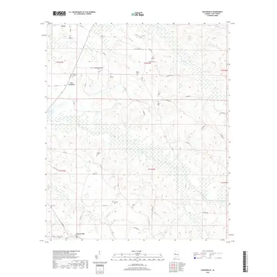
2018 Map of Sawyerville
USGS Topo · Published 2018About this map
Akron and Sawyerville anchor the northern and southern reaches of this Hale County landscape, characterized by numerous family and community burial grounds that reveal the deep-seated settlement history of the area. These sites, including Akron New Cem, Bethlehem Cem, and Mount Hebron Cem, are distributed across a terrain defined by the winding tributaries of the Black Warrior River. The central portion of the map is dominated by the sprawling wetlands of Warrior Lake, while the eastern side is drained by Fivemile Cr and McCrarys Br.
Find a feature on this map
63 named features on this map. Tap any name to fly to it.
Don’t see what you’re looking for? This feature index may not catch every label — zoom into the map to look around manually.
Map Details
Editions of this 2018 Sawyerville Map
This is the sole edition of this map. No revisions or reprints were ever made.
Other maps of this area

1927 · Eutaw
USGS Topo · 1:48,000

1931 · Eutaw
USGS Topo · 1:62,500

1947 · Mason Bend
USGS Topo · 1:24,000

1948 · Mason Bend
USGS Topo · 1:24,000

1953 · Montgomery
USGS Topo · 1:250,000

1956 · Montgomery
USGS Topo · 1:250,000

1957 · Montgomery
USGS Topo · 1:250,000

1979 · Greensboro
USGS Topo · 1:24,000

1980 · Ingram
USGS Topo · 1:24,000
1980 · Moundville West
USGS Topo · 1:24,000