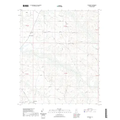
2020 Map of Sawyerville
USGS Topo · Published 2020About this map
Akron and Sawyerville anchor this part of Hale County, defined by a landscape of creeks and numerous small burial grounds that reflect generations of local settlement. The terrain is crisscrossed by an extensive network of waterways, including the winding Fivemile Cr and Big Brush Creek, which drain the lowlands between New Prospect and the surrounding farmland.
Find a feature on this map
60 named features on this map. Tap any name to fly to it.
Don’t see what you’re looking for? This feature index may not catch every label — zoom into the map to look around manually.
Map Details
Editions of this 2020 Sawyerville Map
This is the sole edition of this map. No revisions or reprints were ever made.
Other maps of this area

1927 · Eutaw
USGS Topo · 1:48,000

1931 · Eutaw
USGS Topo · 1:62,500

1947 · Mason Bend
USGS Topo · 1:24,000

1948 · Mason Bend
USGS Topo · 1:24,000

1953 · Montgomery
USGS Topo · 1:250,000

1956 · Montgomery
USGS Topo · 1:250,000

1957 · Montgomery
USGS Topo · 1:250,000

1979 · Greensboro
USGS Topo · 1:24,000

1980 · Ingram
USGS Topo · 1:24,000
1980 · Moundville West
USGS Topo · 1:24,000