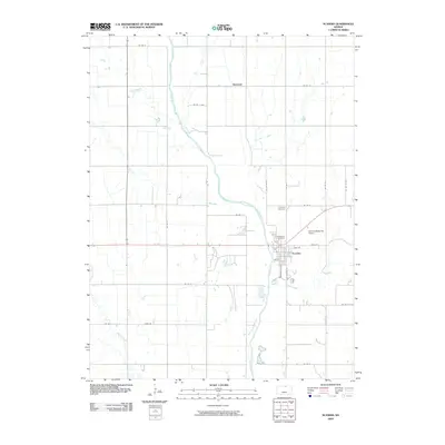
2009 Map of Scandia
USGS Topo · Published 2009About this map
The Republican River carves a diagonal path through this agricultural landscape in Republic County, anchoring the town of Scandia on its eastern banks. This area of Kansas is defined by its deep reliance on water and transport, where the river meets a grid of rural roads and state highways. To the north, the small settlement of Sherdahl sits near the headwaters of Dry Creek, while the town of Scandia shows a developed grid with streets like Washington St and S Kansas St. Local aviation is represented by the Scandia-Belleville Airport, located just northeast of the town center. The map also documents significant local heritage sites, including Riverview Cemetery overlooking the river and the Lutheran Cemetery further north, which alongside landmarks like School Creek and Mud Creek, provide a detailed view of the rural geography and community infrastructure in the early 21st century.
Find a feature on this map
32 named features on this map. Tap any name to fly to it.
Don’t see what you’re looking for? This feature index may not catch every label — zoom into the map to look around manually.
Map Details
Editions of this 2009 Scandia Map
This is the sole edition of this map. No revisions or reprints were ever made.
Other maps of this area

1892 · Concordia
USGS Topo · 1:125,000

1955 · Manhattan
USGS Topo · 1:250,000

1956 · Manhattan
USGS Topo · 1:250,000

1957 · Manhattan
USGS Topo · 1:250,000

1965 · Concordia NW
USGS Topo · 1:24,000

1965 · Kackley
USGS Topo · 1:24,000

1966 · Scandia
USGS Topo · 1:24,000
1966 · Belleville
USGS Topo · 1:24,000
1968 · Jamestown NW
USGS Topo · 1:24,000
1968 · Belleville NW
USGS Topo · 1:24,000